Articles from:November 2021

  • Welcoming Dr. Katie Young

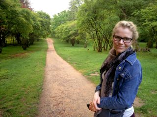
    The Department of Geography and Tourism Studies is pleased to introduce the newest member of our Department, Dr. Katie Young. Dr. Young has joined Dr. Catherine Nash as a Postdoctoral Research Fellow on the Beyond Opposition research project.

    Dr. Young is an arts-based ethnographer, exploring everyday experiences of space through the lens of music and media. Prior to joining the Beyond Opposition project, Dr. Young was a postdoctoral research fellow at the University of Limerick between 2020 and 2021. In Ireland, her research explored experiences of night space for Black-Irish and African diasporic musicians and creatives living in Cork and Galway.

    Katie’s doctoral research focussed on gendered experiences of Hindi films and film music in the home and in everyday life in Ghana. After receiving her PhD in Music and Geography in 2019, she was the 2019 African Studies Association UK Teaching Fellow at the University for Development Studies in Northern Ghana.

    Learn more about Dr. Young and her research here.
    Tags: , , , , ,
    Categories: News

  • New paper by Kevin Turner “Isotopic evidence of increasing water abundance and lake hydrological change in Old Crow Flats, Yukon, Canada”

    A new paper titled, “Isotopic evidence of increasing water abundance and lake hydrological change in Old Crow Flats, Yukon, Canada” co-authored by GeoTour Associate Professor, Dr. Kevin Turner, was recently published in Environmental Research Letters.

    Abstract:
    Lake-rich northern permafrost landscapes are sensitive to changing climate conditions, but ability to track real-time and potentially multiple hydrological responses (e.g. lake expansion, drawdown, drainage) is challenging due to absence of long-term, sustainable monitoring programs in these remote locations. Old Crow Flats (OCF), Yukon, is a Ramsar Wetland of International Importance where concerns about low water levels and their consequences for wildlife habitat and traditional ways of life prompted multidisciplinary studies during the International Polar Year (2007–2008) and led to the establishment of an aquatic ecosystem monitoring program. Here, we report water isotope data from 14 representative thermokarst lakes in OCF, the foundation of the monitoring program, and time-series of derived metrics including the isotope composition of input waters and evaporation-to-inflow ratios for a 13 year period (2007–2019). Although the lakes spanned multiple hydrological categories (i.e. rainfall-, snowmelt- and evaporation-dominated) based on initial surveys, well-defined trends from application of generalized additive models and meteorological records reveal that lakes have become increasingly influenced by rainfall, and potentially waters from thawing permafrost. These sources of input have led to more positive lake water balances. Given the documented role of rainfall in causing thermokarst lake drainage events in OCF and elsewhere, we anticipate increased vulnerability of lateral water export from OCF. This study demonstrates the value of long-term isotope-based monitoring programs for identifying hydrological consequences of climate change in lake-rich permafrost landscapes.

    Reference:
    MacDonald, L.A., Turner, K.W., McDonald, I., Kay, M.L., Hall, R.I., and Wolfe, B.B. (2021). Isotopic evidence of increasing water abundance and lake hydrological change in Old Crow Flats, Yukon, Canada. Environmental Research Letters, 16(12): online.

    Tags: , , , , ,
    Categories: News

  • New paper by Dragos Simandan “Social capital, population health, and the gendered statistics of cardiovascular and all-cause mortality”

    A new paper titled, “Social capital, population health, and the gendered statistics of cardiovascular and all-cause mortality” by Professor Dr. Dragos Simandan was recently published in SSM – Population Health.

    Abstract:
    Scholars in the field of population health need to be on the constant lookout for the danger that their tacit ideological commitments translate into systematic biases in how they interpret their empirical results. This contribution illustrates this problematic by critically interrogating a set of concepts such as tradition, trust, social capital, community, or gender, that are routinely used in population health research even though they carry a barely acknowledged political and ideological load. Alongside this wider deconstruction of loaded concepts, I engage critically but constructively with Martin Lindström et al.’s paper “Social capital, the miniaturization of community, traditionalism and mortality: A population-based prospective cohort study in southern Sweden” to evaluate the extent to which it fits with other empirical findings in the extant literature. Taking as a point of departure the intriguing finding that social capital predicts cardiovascular and all-cause mortality only for men, but not for women, I argue that future research on the nexus of social capital, health, and mortality needs to frame gender not only as a demographic and statistical variable, but also as an ontological conundrum and as an epistemological sensibility.

      Reference:
      Simandan. D. (2021). Social capital, population health, and the gendered statistics of cardiovascular and all-cause mortality. SSM – Population Health, 16: online.

      Tags: , , , ,
      Categories: News

    • New paper by Julia Baird “Ecosystem services decision support tools: exploring the implementation gap in Canada”

      A new paper titled, “Ecosystem services decision support tools: exploring the implementation gap in Canada” by Dr. Julia Baird was recently published in FACETS.

      Abstract:
      This paper explores the degree to which the ecosystem services (ES) concept and related tools have been integrated and implemented within the Canadian government context at both the provincial/territorial and federal levels. The research goals of the study were to qualitatively assess the extent to which ES assessment is being integrated at different levels of government, consider the barriers to implementation, and draw lessons from the development and use of Canada’s Ecosystem Services Toolkit: Completing and Using Ecosystem Service Assessment for Decision-Making—An Interdisciplinary Toolkit for Managers and Analysts (2017), jointly developed by a federal, provincial, and territorial government task force. Primary data were collected through targeted semi-structured interviews with key informants combined with a content analysis of ES-related documentation from government websites. Results indicate that while the term ES is found in documentation across different levels of government, there appears to be an ES implementation gap. Issues of conceptual understanding, path dependency, a lack of regulatory mandate, lost staff expertise, and competition with overlapping conceptual approaches were identified as barriers to ES uptake. Areas requiring further policy and research attention are identified.

      Citation:
      Kerr, G.L., Holzer, J.M., Baird, J., and Hickey, G.M. (2021). Ecosystem services decision support tools: exploring the implementation gap in Canada. FACETS, 18: online.

      Tags: , ,
      Categories: News

    • Micheal Ripmeester featured on The Brown Homestead Podcast

      Dr. Mike Ripmeester was recently interviewed on The Brown Homestead podcast to discuss the controversial statue of Private Alexander Watson that sits in front of St. Catharines City Hall.

      Episode 5: What to do about Watson

      In this episode, we dig into the complicated question of what to do about the controversial statue to Private Alexander Watson in front of St. Catharines City Hall. Brock University professors Michael Ripmeester (GeoTour) and Russell Johnston examine the complex history of the monument and walk us through ways that its challenging narrative offers opportunities for education and reconciliation.

      Listen here.

      Tags: , , ,
      Categories: News

    • Brock to celebrate GIS Days with week of online events

      Brock will join institutions from around the world in celebrating Geographic Information Systems (GIS) Days by participating in a free weeklong virtual conference that is packed with events open to the University community.

      GIS Days 2021 features more than 50 online presentations, tutorials and demonstrations taking place Monday, Nov. 15 to Friday, Nov. 19 from 9:30 a.m. to 4:30 p.m. each day.

      Several representatives from the Brock community — an alumna, a master’s student, a lecturer and a librarian — will each be presenting a seven-minute ‘lightning talk’ on projects they’ve worked on using GIS tools such as geovisualization, geospatial technologies and story mapping.

      Isaac Williams, GIS and Data Services Librarian with the Brock University Library, who will present Story Mapping Queer Dallas on Monday at 9:30 a.m, said the breadth of disciplines that can use GIS is part of what makes the technology so compelling.

      “I think a lot of people associate GIS with geology or earth sciences, but you can use it in any field that involves something you want to locate,” they said. “There is a lot of interesting work being done across disciplines. I have done some work with GIS in humanities contexts, for example, mapping existing geographies, but also historical geographies such as the ones found in ancient Roman literature.”

      Sharon Janzen, Brock’s Map Library Associate and Geospatial Data Co-ordinator, will be leading a one-hour tutorial Friday at 2 p.m. that introduces participants to ArcGIS Online, a web-based mapping software.

      She says GIS Days is an opportunity to experience the variety of GIS usage across educational institutions and the public sector, and encourages the Brock community to register for some of the free events.

      “Whether an attendee comes with little knowledge of GIS or they have been using GIS their whole career, the conference will be sure to not disappoint,” she said. “From the geography of Pokémon Go and the movement of muskox, to Esri technology and Open Source QGIS, sign up for what’s sure to be the GIS highlight of the year.”

      Registration is required to access events; however, there is no registration deadline. Registration can take place minutes before a presentation begins.

      Learn more about GIS Days events, including this year’s schedule, by visiting the event web page. The interactive program can be used to search by presenter, presentation title or location.

      Brock University GIS Days events

      Story Mapping Queer Dallas
      Monday, Nov. 15 at 9:30 a.m. — Seven-minute lightning talk
      Presented by Isaac Williams, GIS and Data Services Librarian, Brock University Library

      Queer Dallas StoryMap is a project highlighting queer history in Dallas, Texas. The American South is home to a rich history of past and present queer life, organizing, survival and joy. The project’s goal was to make this history more visible to Southerners and people who live elsewhere. The presentation will discuss resources used in the creation of the project, decisions made in the visualization process and ways the project was shared.

      Researching Military Service using Geovisualization in Eleventh to Twelfth Century Normandy
      Wednesday, Nov. 17 at 11 a.m. — Seven-minute lightning talk
      Presented by Christopher Hewitt, Lecturer, Geography and Tourism Studies, Brock University

      In the 11th and 12th centuries, the Duchy of Normandy was an important source for military adventurers. While much has been written about soldiers who fought on these campaigns, little has been written about where they originated. This study demonstrates the value of geographic-based analysis through the use of historical geographic information systems (HGIS) techniques, including mapping locations as well as performing nearest neighbour analysis and kernel density mapping. The presentation will conclude with a discussion of the implications of these findings and the options for and benefits of applying HGIS analysis to other historical events.

      Using GIS to Re-imagine Historical Niagara
      Wednesday, Nov. 17 at 11 a.m. — Seven-minute lightning talk
      Presented by Brock alumna Jessica Linzel (BA ’18, MA ’20), Historical Researcher

      Linzel will explain how she incorporated historical GIS into her History master’s thesis. She used ArcGIS Pro to create a web map, which she then used to investigate Niagara’s economic development in the post-Revolutionary ‘Loyalist’ era. By mapping historical data from account books and ledgers and analyzing it alongside geographical features in the Niagara region, GIS technologies allowed her to bring a fresh perspective to a familiar topic.

      Using Geospatial Technologies: A Case Study of the Town of Lincoln, Ontario
      Wednesday, Nov. 17 at 2 p.m. — Seven-minute lightning talk
      Presented by Baharak Razaghirad, Brock University Master of Sustainability student

      Urban trees provide important benefits to communities, especially in the context of climate change. This presentation will discuss using geospacial technologies to assess urban tree canopies as a timely and accurate alternative to costly, ground-based assessments.  Razaghirad will discuss two approaches used to quantify the urban tree canopy for the Town of Lincoln —  remote sensing and a random sampling method.

      Introduction to ArcGIS Online
      Friday, Nov. 19 at 2 p.m. — One-hour tutorial
      Presented by Sharon Janzen, Map Library Associate and Geospatial Data Co-ordinator, Brock University

      During this hands-on experience, participants will explore ArcGIS Online, a popular web-based dynamic mapping software that is accessible on Windows and Mac platforms. No experience is necessary for this introductory tutorial, but curiosity is an asset. A valid login for the website is required (public or organizational accounts welcome). Visit the ArcGIS website to sign up for a public account.

      STORY FROM THE BROCK NEWS

      Tags: , , , , , ,
      Categories: News

    • Five Brock courses with a focus on climate change

      As the COP26 climate summit continues with world leaders talking climate change in Glasgow, Scotland, the topic is also at the forefront of both research and courses at Brock University. Climate change and its effects is discussed in various Faculties and from a variety of angles at Brock. Here are five examples of how students are learning about climate change.

      Contemporary Environmental Issues

      ENSU 3P90 is an Environmental Sustainability capstone course for Brock students who share an interest in sustainability and a concern for improving the relationships between people and the planet. Students engage in a wide range of sustainability issues, including climate change and biodiversity loss as well as displacement and environmental racism.

      The course’s instructor, Jessica Blythe, Assistant Professor in Brock’s Environmental Sustainability Research Centre, says it resonates with students who are seeking to make a positive change in the world.

      “Many members of Gen Z feel overwhelmed by the state of the world and are responding by devoting their professional careers to finding solutions,” she said. “This course is designed to help students develop core competencies in sustainability science, including systems thinking, anticipatory and strategic skills, so they can thrive in sustainability careers and contribute to addressing the climate crisis.”

      Watershed Study and Assessment

      ERSC 4P31 is an Earth Sciences course that looks at the environmental health of two branches of the upper Twelve Mile Creek. Students in the course measure water quality parameters under different ambient conditions. They then get to compare their results with historical ones obtained in 1978 and 2001.

      Professor of Earth Sciences and course instructor Uwe Brand said the exercise encourages participants to re-evaluate their perceptions of clean water and its availability.

      “The course should show them that water is not only important to the fauna of the creek but also speaks to our water security,” he said. “In light of increasing CO2 emissions and global warming, don’t take anything for granted, including access to ‘clean’ water.”

      Environmental Economics

      ECON/TOUR 2P28 is a course that provides Economic perspectives on environmental and natural resource issues. Economics Instructor Geoff Black, who leads the course, said it is often an eye-opening experience for students.

      “We look at ways in which this shortcoming can be modelled and investigate policy that can bridge the gap,” he said. “It’s important for students to understand the market failures that occur regarding both common resources and public goods.”

      Ecocinema: History, Theory, Practices

      COMM/FILM/PCUL 4P58 is a Film Studies course that explores the proliferation of both fiction and nonfiction films that deal with the climate change, species extinction, resource extraction and other industrial practices.

      Course instructor Christie Milliken, Associate Professor of Film Studies, said the topic of climate change has been more prevalent in recent years, but it was also common in science fiction films in earlier decades.

      “The course invites students to consider the various rhetorical strategies deployed across a range of films as they invite us to rethink our relationship to the planet,” she said.

      Climate Crisis

      GEOG/ERSC 2P08 is a Geography course that provides an Introduction to the Earth’s atmosphere and the natural and anthropogenic drivers that change the Earth’s climate system. These include the Greenhouse effect, human activities that alter the climate system, climate models, climates of the past and projections of future climate.


      STORY REPOSTED FROM THE BROCK NEWS

      Tags: , , , , , , ,
      Categories: News