Seismic Waves (Click here to a MSWord version of this page.)
| During an earthquake two main types of waves are generated. The first type of wave is a compression wave. Compression waves have small amplitudes and can travel at around 4.8 - 8 km (3-5 miles) per second. Compression waves travel by pushing and pulling. Shear waves on the other hand have larger amplitudes and travel at a slower speed, and move from side to side or up and down. The velocity of a shear wave can range from 3.2-4.8 km (2-3 miles) per second. Because compression waves travel at a faster speed they are also know as primary waves or P waves. Shear waves on the other hand are also known as secondary waves or S waves. It is due to the impact of these seismic waves that buildings are damaged. | |
|
1) |
Prince George is a small city 600km north of Vancouver. The average velocity of a P wave is 6 km/second and the average velocity of the S wave is 4 km /second. If there was an earthquake originating in Prince George, how much sooner would the P wave reach Vancouver than the S wave? |
| 2) | If scientists inaccurately pinpointed the centre of the quake, and have traced its true origin to a city farther away than 600km, would the distance between the arrival of P and S wave be greater or less than that of Prince George? Explain your answer. |
|
|
|
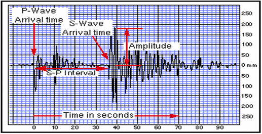
If you were to mark a point 500km in all directions starting from Vancouver, then what you will end up with is a circle. Any point on this circle is a potential epicentre. To locate the centre to the earthquake (epicentre), various seismograms are analyzed for the lag time (time difference) between the P and S waves. The P waves are easy to identify because they are always first to arrive and their amplitude is smaller than the S wave. S waves are indicated by an abrupt change in wave amplitude. In the seismogram below, we see that the S wave arrived at about 34 sec after the P wave arrived. This time difference is called the S-P interval and is the lag time between the P and S wave.
|
3) |
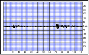
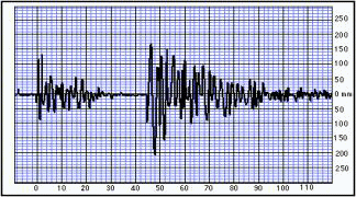
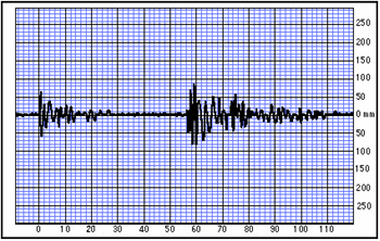
Below are examples of three seismograms taken at three different recording stations around B.C. Which station is closest to the earthquake and which one is farthest away from the earthquake? Explain your answer. | ||||||
|
|||||||
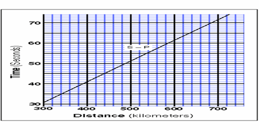
The next step to figuring out the epicentre is to relate the time interval to distance. To do this a standard line graph is provided. On the Y axis is the time interval and on the X axis is the distance from the epicentre.
|
4) |
If the time interval between P and S waves is 40 seconds, how far away is the centre of the quake? |
| 5) | If the distance of the epicentre is found to be is 650km away from the seismograph station, predict what the time interval would be for the P and S wave. |
|
|
|
In order to pinpoint the exact location of the epicentre we need to analyze several seismograms. Using only one seismogram, one can only know how far the epicentre is away from that recording station. It does not indicate the direction from the epicentre. For example, if we can deduce that the epicentre is 500 km away from Vancouver, then any place which is 500 km away from Vancouver is a potential location.
By using several seismograms at various locations, we can pinpoint the exact location of the epicentre by the intersection of the circles.
|
6) |
What is the minimum number of seismograms needed in order to find the epicentre? Explain. |
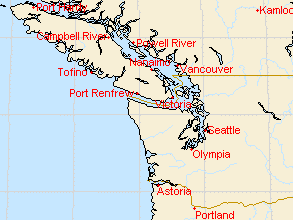
For the following question, use the seismogram above and map. Drawing a grid over the map may help.
|
7) |
Given the seismogram of a recording station in Nelson (above), indicate on the map ALL of the areas which are possible epicentres. |
| 8) | Using the seismograms at different locations (Vernon and Cranbrook) plot on the map where the epicentre is located. |
|
!!! Challenge problems: Derive the formula for each circle drawn. Using the derived formulas, solve for the intersection of the three circles. Does your answer match up with what you had before? Based on the map of B.C., if we know
that the epicentre is located in Victoria, what would the time interval be on
the seismogram at the recording station in: |
|
Once you have completed these activities, you are prepared to learn about the Richter Scale.
Source of seismograms: http://vcourseware3.calstatela.edu/VirtualEarthquake/php/QuakeScript.php
| See solutions to the questions. |
Back to Earthquake Math Trail Home |