Math Trail
Introduction
Information
about Vancouver
Vancouver Population
The Vancouver Metropolitan Area,
also known as "The Lower Mainland" or the "Greater Vancouver
Regional District (GVRD)", is not really one city but many. Due to a
steady increase in population in the last 20 years
these cities have grown together and are often collectively known as
Vancouver even though technically this is not the case.
Before we begin looking at
"The Lower Mainland" let's discuss how the province of British
Columbia compares to the rest of Canada. Consider the information taken
from the 2001 and 1996 Census data:
| Name |
Population |
| 2001 |
1996 |
| Canada |
30,007,094 |
28,846,761 |
| Newfoundland and Labrador |
512,930 |
551,792 |
| Prince Edward Island |
135,294 |
134,557 |
| Nova Scotia |
908,007 |
909,282 |
| New Brunswick |
729,498 |
738,133 |
| Quebec |
7,237,479 |
7,138,795 |
| Ontario |
11,410,046 |
10,753,573 |
| Manitoba |
1,119,583 |
1,113,898 |
| Saskatchewan |
978,933 |
990,237 |
| Alberta |
2,974,807 |
2,696,826 |
| British Columbia |
3,907,738 |
3,724,500 |
| Yukon Territory |
28,674 |
30,766 |
| Northwest Territories |
37,360 |
39,672 |
| Nunavut |
26,745 |
24,730 |
Taken directly from Statistics Canada: http://www12.statcan.ca/english/census01/products/standard/popdwell/Table-PR.cfm
1.
What
province contains the largest percentage of the population? What is this
percentage? Solution
2.
How
has British Columbia's population changed from 1996 to 2001? Can you
state this change as a percentage? Solution
For the purpose of this Math Trail, we will consider the "Lower
Mainland" to be a grouping of 18 cities:
Consider the population of a number of the cities that make
up the Lower Mainland:
| Name |
Population |
| 2001 |
1996 |
| Canada |
30,007,094 |
28,846,761 |
| British Columbia |
3,907,738 |
3,724,500 |
|
Burnaby
|
193,954 |
179,209 |
| Richmond |
164,345 |
148,867 |
|
Surrey
|
347,825 |
304,477 |
|
Vancouver
|
545,671 |
514,008 |
Taken directly from Statistics
Canada: http://www12.statcan.ca/english/census01/products/standard/popdwell/Table-CSD-P.cfm?PR=59
3.
What
percentage of the British Columbia population was found in the city of
Richmond in 2001? Solution
Vancouver
Geography
One of the main causes of
traffic problems in the city is the geography of the area as well as the
roadway infrastructure that is being overtaxed. The fact that the
two arms of the Fraser River surround much of the Lower Mainland means that
anyone travelling must cross a number of bridges each day. (And this is quite
different from many other cities who traffic flow is not contained by the
"bottleneck" of bridges.)
The website Vancouver:
Spectacular By Nature offers the following description of the Lower
Mainland as it relates to the city of Vancouver. "The city is on
the western-most part of a peninsula that is a major extension of the Fraser
River's delta. Several self-governing urban areas called municipalities make
up Greater Vancouver. Six of them-Burnaby, New Westminster, Coquitlam, Port
Coquitlam and Port Moody-are east of Vancouver. North Vancouver and West
Vancouver (located on the "North Shore") are to the north of
Vancouver, separated from it by Burrard Inlet."
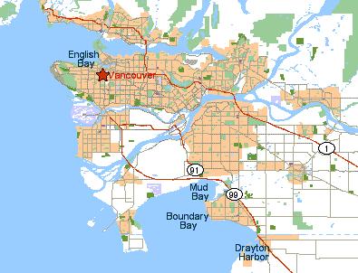 |
"The southern boundary of
the City of Vancouver is the North Arm of the Fraser River, one of the
largest rivers entering the Pacific. On the opposite shore of the Fraser
River are the lowland Greater Vancouver municipalities: Richmond, Delta,
Surrey, White Rock and Langley.
Thirty-eight kilometres (24 miles) south of downtown Vancouver is the
Canada-US boundary."
To see a better view of the Lower Mainland (or GVRD) check out this PDF
file. |
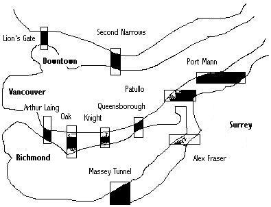
| The need for bridges is clearly evident given all the
water that exists in and around the Vancouver area but it is astounding
to think that there are 9 bridges and one tunnel spanning different arms
of the Fraser River and the Burrard Inlet. 4.
How
many bodies of water (if any) exist around your city or town? How
many bridges have been built to cross these expanses? Solution
|
 |
To get us started thinking about
what it means to have to cross many bridges consider a Math problem first
considered a long time ago:
A
Classic
Math Problem: The Seven Bridges of Konigsberg
| There was a city in Germany called Konigsberg that
was a lot like Vancouver in that it had a river running through
and around it. There was even an island in the middle of the river
after which the river separated into two parts. Seven bridges were built so that the people of the city could
get from one part to another. A crude map of the center of Konigsberg
might look like this: |
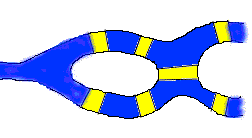
Courtesy: Math
Forum Graph Theory |
The
people wondered whether or not one could walk around the city in a way
that would involve crossing each bridge exactly once. Actually
a famous Mathematician Leonard Euler also took the time to think about
this and actually came up with a proof to show that there is no
solution. See the Math
Forum Explanation.
You
may want to work on this problem with your
teacher and fellow classmates as it is
quite difficult. For more help check out the following website: Math
Forum Graph Theory.
So is there other similar
problems for which there might be a solution? The
answer is yes and let's have a look at that:
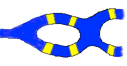
| 5.
(BONUS QUESTION)
Suppose you removed one of the bridges as in the diagram to the right? Can
you solve the problem now? Solution
|
 |
6. Using
the rough diagram of the bridges (and tunnel) surrounding Vancouver can you
determine how many ways (using different bridge combinations) there are
to get from Surrey to Downtown Vancouver? Solution
Causes
of Traffic
As we begin to think about more
questions concerning traffic let's take a moment to brainstorm about the
reason that traffic occurs. For example, bridges that create
"bottleneck" situations are one problem.
7.
Create a list describing a number of
different reasons for traffic jams and congestion in the Lower
Mainland? Are these different from the reasons that there may or may not be
traffic where you live? Solution
Travel
Time
What
do you suppose is the fastest way to get around Vancouver?
At
certain times, for example at two o'clock in the morning, it is definitely
the fastest to travel by car. However,
at other times – rush hour – it is actually just as fast, if not faster
to bike than to drive if the place you are going is less than 5 km away!
Despite
this shocking fact, of the 28% of people live within 5 km of their work, only
16% of them biked to work at least once in 6 months.
(Information
taken from the TransLink
(BC Public Transit) website and the Statistics
Canada website.)
8.
What percentage of the total population does this 16% represent?
Solution
In
Vancouver, it is actually possible to bike almost year round, since it almost
never snows. There are many
beautiful streets and paths set apart for cycling around Vancouver, such as
the sea wall.
9.
Why do you think more people do not cycle?
Solution
A
big reason for many people is that they feel it is not very safe to cycle.
53%
of drivers, 39 % of recreational cyclists, and 34 % of non-recreational
cyclists believe that cycling is not safe.
In
2001, the number of people injured in traffic accidents (as reported to the
police) was 27, 314. Of this
number, 1007 were bicyclists, 1723 were pedestrians, 23 620 were in a
vehicle, 819 were motorcyclists, and 145 were in some other mode of
transportation.
10.
What percentage of the victims were cyclists? Pedestrians? In
a vehicle? Based on your calculations,
what do you think is the most dangerous form of transportation?
Solution
Of
course, if you are in a collision while riding your bike, the potential of
getting hurt is much greater than if you are in a vehicle because you are so
much more vulnerable. However,
out of the 414 people who died in collisions in 2001, only 4 were cyclists.
56 were pedestrians, 319 were in a vehicle, and 32 were on a
motorcycle.
11.
What percentage of the fatalities were in each type of transportation?
Which do you think is the most dangerous form, and do the statistics
agree? What important fact is missing from these statistics? Solution
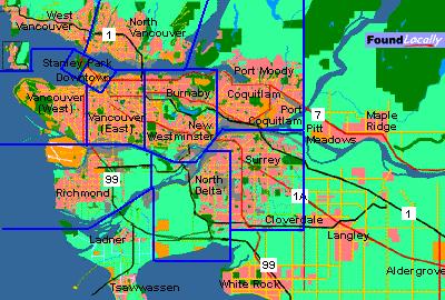 Map Courtesy of http://www.foundlocally.com/Vancouver/Travel/Maps.htm