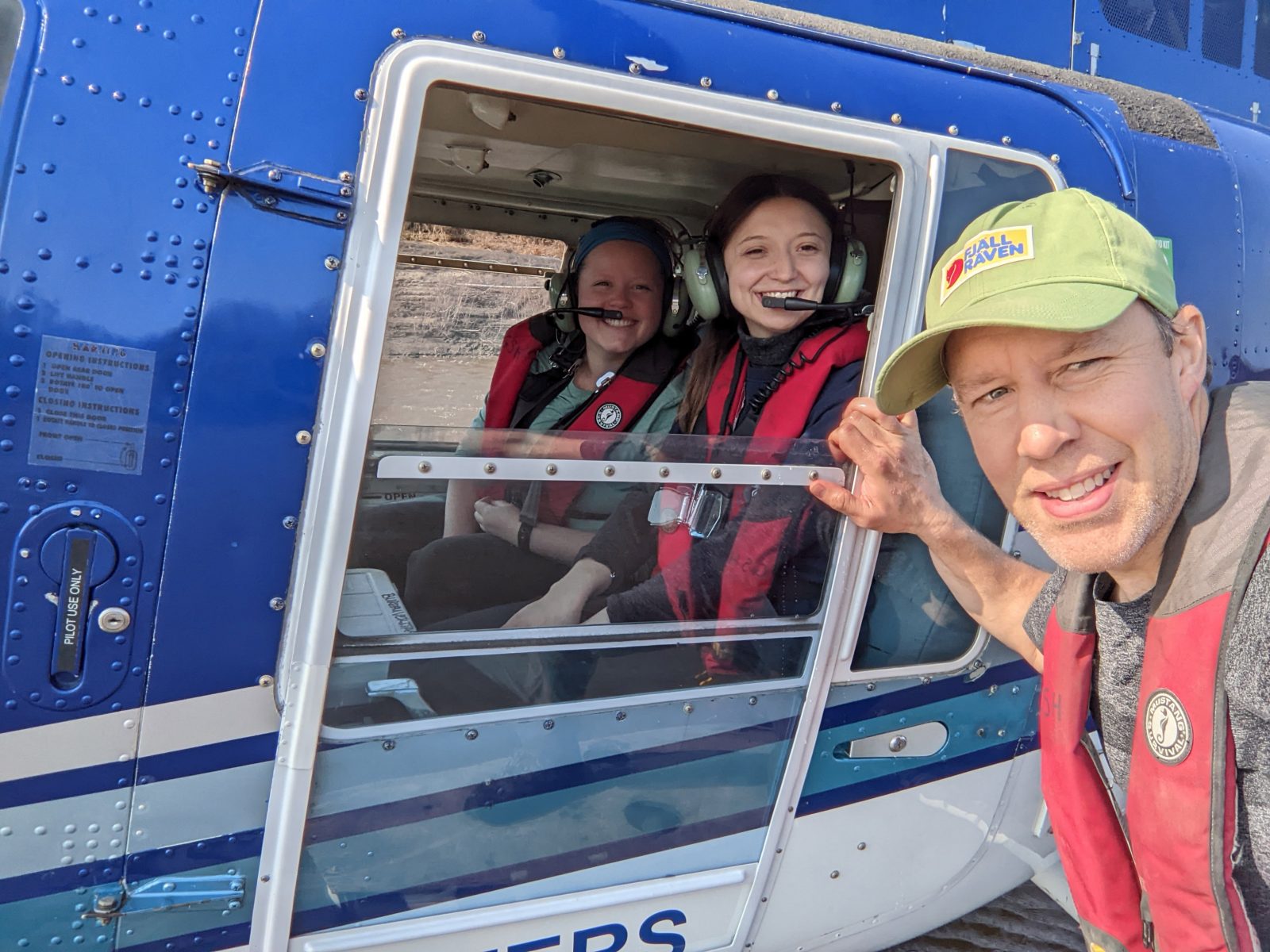
Articles tagged with: fieldwork

  • Brock geographer makes global connections during Fulbright Canada residency

    Almost two years after his Fulbright Canada Research Chair in Arctic Studies at the University of Washington was first announced, Kevin Turner is winding down his duties.

    The award normally involves a six-month residency, but the global pandemic prevented the Associate Professor in Brock University’s Departments of Geography and Tourism Studies and Earth Sciences from travelling to Seattle as expected.

    Instead, he virtually taught a fourth-year course in Arctic Landscape Change and Detection, conducted workshops for teachers and engaged in events hosted by the World Affairs Council, including a fireside chat with Chief Tizya-Tramm of the Vuntut Gwitchin Government through winter 2021.

    Earlier this spring, he was finally able to load his truck with his bikes and some field equipment and head west for his required in-person residency at the University of Washington.

    In spite of a hectic three-month schedule, Turner says the trip has created opportunities to meet up and collaborate with colleagues, sometimes in unexpected ways.

    In May, he travelled to Fairbanks, Alaska, for a meeting of NASA’s Arctic Boreal Vulnerability Experiment (ABoVE) Science Team. As a research affiliate of that program, he advises on airborne data acquisition and suggests key flyover locations from his main research site in Old Crow.

    “Being an affiliate of NASA ABoVE, I can help guide where they fly in northern Yukon and then utilize the data they collect within my research program, as can many others,” says Turner. “We also learn the latest on some of the cool things that colleagues are doing with the data to assess landscape conditions across the north, as well as share our own findings.”

    He attended a meeting of the International Circumpolar Remote Sensing Symposium in Fairbanks, which attracted top scholars from around the world, and was also involved in fieldwork being done by colleagues from University of Alaska, Fairbanks and the NASA Jet Propulsion Lab.

    “I was able to use some equipment I brought with me because I didn’t want it sitting in the truck at the airport while I travelled,” Turner says. “When I took it out for a little bit of show and tell, they invited me to visit one of their research sites to try it out.”

    Upon his return to Seattle, the University of Washington hosted Turner, Tram Nguyen, the 2021-22 Fulbright Canada Chair in Arctic Studies, and others for a roundtable discussion in late May on “Holistic Approaches to Health and Wellbeing in Arctic Communities and Beyond.”

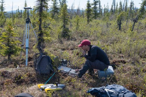
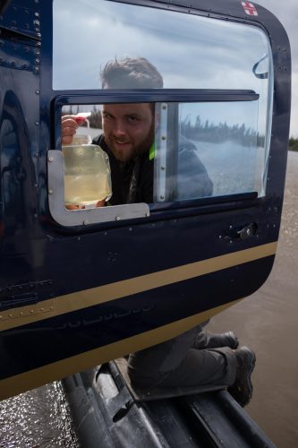
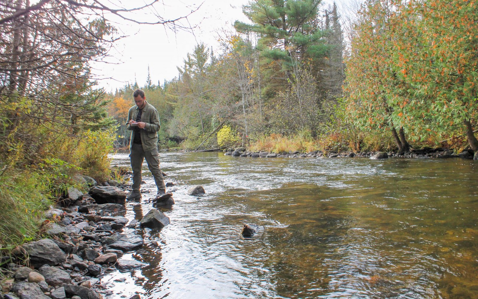
    In June, Turner flew north again for fieldwork in Old Crow, Yukon. The strict parameters of his VISA required him to travel on specific dates — which can be hard to commit to when research excursions are delayed by Arctic weather.

    Turner counted on Brock Earth Sciences graduate student Michelle Pearce (BSc ’20) and undergraduate student Marley Tessier to help him meet the logistical challenges of the research trip and collaborated with colleagues from Polar Knowledge Canada and Parks Canada, along with local Indigenous community members, including photographer and drone pilot, Caleb Charlie, to collect data. Turner also credits helicopter pilot Ruth Hardy with being able to work wonders in small time frames.

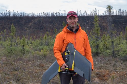
    In addition to gathering water samples and aerial survey photography, Turner also used a LiDAR sensor — “a Ghostbuster-looking sensor that shoots out 300,000 pulses of light per second” — to collect data for fine-grained 3D imaging of the landscape.

    His use of the LiDAR device was of particular interest to a documentary film crew from France and Germany working on a four-part series on climate change, who accompanied the researchers and interviewed Turner in the midst of the data collection.

    Turner has now returned to Seattle for the rest of July to crunch some data and collaborate with colleagues at the University of Washington.

    Though it hasn’t been without its challenges, he says that he has enjoyed the “shake-up” of the Seattle residency and the Fulbright Chair overall. And he looks forward to soon welcoming his family for a quick holiday in a nearby mountain cabin.

    “If I didn’t have the support of my family, this would be impossible,” he says. “My wife, Jen, is amazing, and my two boys have really stepped up to fill in the gaps of getting things done around the house in my absence. Their ability to carry on with me somewhere else for an extended period has made this smooth, but I really miss them.”

    Tags: , , , , , , , , , , , ,
    Categories: News

  • Studying sustainable transportation in Sweden

    Bus in bus terminal in Gothenburg, Sweden

    Dr. Christopher Fullerton spent part of March in Sweden exploring experiences with electric public transit buses. Here are a few photos from his trip and a reflection from Dr. Fullerton’s second day in Gothenburg:

    “I spent the afternoon at the Lindholmen Science Park learning about Gothenburg’s ElectriCity project, where they are piloting the use of electric buses on two routes and conducting research about all aspects of electric buses. These pictures show their innovative indoor bus stop. It’s a climate controlled building where the bus pulls in at the end of the route, the doors close, the bus’ battery charges in nine minutes, and then the doors open for the bus to leave on its next run. In the meantime, you can wait for the bus in a heated or air conditioned setting, read a book at their mini library or sit in some cool hanging chairs, all the while listening to a recording of birds chirping! When one bus leaves, the next one to arrive pulls in and does the same! Great idea for cities with cold or hot climates, and something that’s much easier to do with quiet and emission-free electric buses.”

    Bridge over river in Gothenburg, Sweden

    Bus terminal waiting room with bookshelves and seating in Gothenburg, Sweden

    Tags: , , , , ,
    Categories: News

  • GoGeomatics interview: Associate Professor Kevin Turner

    STORY REPOSTED FROM GOGEOMATICS | NOVEMBER 22, 2018

    Kevin Turner working on field research in northern Canada. Image by Brent Thorne

    This installment of our ongoing series on GIS and education in Canada features Associate Professor Kevin Turner from Brock University’s Department of Geography and Tourism Studies.

    Jonathan Murphy: Hi Kevin, and thank you for taking the time to chat with us about your career and your program at Brock. How did your passion for geography start?

    Kevin Turner: I was drawn to nature at an early age. I can trace my interests in geography and the natural sciences to various times starting in Grade 6 when Mr. Wayne Graham (Hamlet Public School, Stratford) put the class in contact with Daphne Sheldrick, the operator of an elephant orphanage in Kenya. While it may not have been geography-focused at the time, I became quite aware of the negative influence people can have on the world and the animals within it. My interest in Geography grew during my grade 11 geography class with Mr. Al Vredeveld at Stratford Central Secondary School. I also had the interests of a couple family members rub off on me. Add in a number of nature documentaries, family camping, a couple David Suzuki books, and some great advice from my high school academic advisor (Mrs. Heather Jesson), and soon I was off to Trent for my undergraduate joint major in physical geography and biology. I had some fantastic profs at Trent who continued to lure me into the natural sciences.

    I was a tree planter during summers in northern Ontario, Alberta, and BC, which continued to build my appreciation for the outdoors. I knew that I wanted to study nature in some way and somehow set myself up to have a career that included working outside in a remote landscape. The motivation for this continued after graduation while hiking and mountaineering in Ecuador and Peru.

    I decided that I wanted to learn more about landscape-scale systems and that building skills in digital mapping and spatial analysis was needed. I received a post-grad certificate in the GIS Applications Specialist program at Sir Sandford Fleming College and got my first ‘career’ job at a geophysical exploration firm out of Guelph, Ontario. I found myself designing projects and surveying in nice places around eastern Canada and the US. In addition to coordinating and conducting the field surveys, I wrote scripts in VBA to design the projects and quality check the data coming in, which I reported to clients.

    I wanted more involvement on the research side of things, especially with water resources, and decided to begin graduate studies in 2007 at Wilfrid Laurier University. The timing was right considering that my new supervisor at the time (Dr. Brent Wolfe) and many other colleagues were beginning a multidisciplinary research program in Old Crow Flats, Yukon, supported by the Government of Canada International Polar Year. It was an incredible experience that presented many opportunities to travel to the north for fieldwork and interact with people of the Vuntut Gwitchin First Nation, who were the driving force of the program. Fast-forward 6.5 years and I’m beginning a position at Brock University where I secured external funding to build on my research in northern Yukon and also Northwest Territories.

    Jonathan Murphy: You were recently promoted to associate professor at Brock–congratulations! What do you teach there and what is your research focus?

    Graduate Research Assistant Brent Thorne, Image by Kevin Turner

    Kevin Turner: My teaching focus in the Department of Geography and Tourism Studies at Brock is mostly geomatics. We offer a suite of geomatics courses spanning introduction and advanced remote sensing, GIS, cartography, and quantitative research design and methodology. Once students learn to grasp the various concepts, I encourage them to implement creative and critical analysis with datasets and topics that interest them most. I also strive to make them comfortable with using computer programming for automating tasks so they can accomplish more by generating useful customized tools of their interest. We’ve been lucky to have some very strong students come through our programs and it has been rewarding to see them enjoy and take a lot away from our programs.

    Jonathan Murphy:  What is the geography and tourism program like at Brock?  What makes the program unique?

    Kevin Turner: Within the Department of Geography and Tourism Studies, we have a diverse set of streams that students can pursue, which include the following:

    • BA Geography (focus on human geography)
    • BSc Geography (focus on physical geography)
    • Concurrent BA or BSc (Honours) – Geography/ Education
    • Combined Geography majors (e.g., Geography + Biology, Child and Youth Studies, Computer Science, Earth Sciences, Economics, History Labour Studies, and more)

    We offer seven geomatics-focused courses as well as a fourth-year co-op course where students can gain additional hands-on experience in a position of their choosing. The wide-ranging options available provide students with the ability to shape their studies according to their interests. I take this approach with the four geomatics (i.e., mostly GIS and spatial analysis and statistics) courses that I teach. Students learn essential GIS/RS skills for evaluating spatial patterns throughout my courses and have opportunities to implement them within the context of their choice. The aim is to build their knowledge of geography and related fields through enhancing their analytical capabilities. We are lucky to work with the Brock University Map, GIS, and Data Library, which is conveniently located beside our department where students can have access to necessary resources for building their skills in geomatics. I pull a lot from my private sector and ongoing academic research experiences when updating and implementing my courses. I’m happy to report that following graduation, many students who have taken our courses have been quite successful at finding employment and/or additional research programs in their fields of interest.

    Jonathan Murphy:  What geomatics classes or skills are students acquiring by the time they graduate from Brock?

    Kevin Turner. Image by Brent Thorne

    Kevin Turner: Students learn to use many GIS/RS software for their analytical needs and interests. We have many computer labs throughout Brock University with site licenses for ESRI products including ArcMap and ArcGIS Pro as well as ENVI for remote sensing analyses. My courses also include a lot of content focused on open source solutions including R, QGIS, and various integrated development environments. In addition to utilizing databases for spatial analyses (3D, network, spatial statistical, etc.) and geoprocessing, my courses bring in application development so that they can learn to automate or customize their workflow in an effort to eliminate redundancies. This comes from using Python and R programming languages.

    Jonathan Murphy: The program has some interesting aspects to it.  Can you tell us a bit about the weeklong experiential learning exercise in central Ontario for the fourth year students?

    Kevin Turner: We have several ‘experiential learning’ opportunities within our programs. It is geography after all and it is important to get students into the field to get hands-on experience. The Peterborough field course is the longest running one in the department where physical and human geography students get a chance to conduct their research of interest. We offer additional field courses for geography and tourism students to other national and international destinations that have included Croatia, Vancouver, and Chicago. London, England is on the list for next year. I take graduate and undergraduate students who are working on their theses for Geography and Tourism Studies or Earth Science with me to my northern study sites including Old Crow, Yukon, and Yellowknife, Northwest Territories.

    Jonathan Murphy: I understand that 40% of your job is focused on research. Can you describe your research program and how you and the students working with you accomplish it?

    Research Assistant Brent Thorne. Image by Kevin Turner

    Kevin Turner: My research program focuses on tracking climate-induced landscape changes and the associated responses of lakes and rivers in northern Canada. For example, the changes that myself and the people of Old Crow, Yukon have observed include an increased frequency of lake drainage, shoreline permafrost thaw slumping (i.e., landslides), shrub vegetation proliferation, and fire. Taking inventory of these phenomena requires the use of available remotely sensed data products and multispectral imagery we collect using unmanned aerial vehicles. Other datasets are coming from airborne campaigns of the NASA Arctic Boreal Vulnerability Experiment, which I am affiliated with. We also sample water and sediment from lakes and rivers, which undergoes a suite of water chemistry and isotope analysis. This information provides an indication of how the landscape changes have impacted water quality, hydrology and carbon export over multiple temporal scales.

    Geomatics tools are essential at all stages of the research process including data acquisition, processing, analysis and integration of final catchment map layers (e.g., ground conditions, land cover type, ground temperatures, etc.). We also identify where lakes and rivers across the study sites are more vulnerable to being impacted by changing climate and landscape features. The overall aim is to provide key insight required for predicting how these places will respond to future change and how that will impact downstream environments.

    Managing a northern research program in a southern Canada university can be a challenge. However, it is a chance of a lifetime for the students to venture out to important remote Canadian landscapes and work with stakeholders, including those who want to learn about the spatial patterns we see in their traditional territories.

    Jonathan Murphy: Thanks for taking the time to talk to the GoGeomatics community.  We hope to see you and your students at our monthly GoGeomatics socials in Niagara!

    STORY REPOSTED FROM GOGEOMATICS

    Tags: , , ,
    Categories: News

  • Geography and Tourism students put skills to the test in central Ontario

    A crisp fall breeze and the smell of pine recently welcomed Daniel Marshall into a different type of learning environment.

    The fourth-year Geography student can normally be found deep in the Mackenzie Chown Complex learning about physical geography. But, during this year’s fall Reading Week, an experiential education trip took him out of his comfort zone and into the field.

    Along with 34 other participants from the Geography and Tourism Department’s Physical Geography and Human Geography and Tourism Studies field courses, Marshall took part in a weeklong experiential learning exercise in central Ontario. The annual trip is designed to connect in-class learning with practical on-site research skills that are necessary for all geographers.

    “Sometimes in the classroom you lose focus on what you are actually studying,” Marshall said. “To be in the field and make the observations myself and get my feet muddy allowed everything to come full circle.”

    While the human geographers and tourism students went into Peterborough to gather data, Marshall and his fellow physical geographers went further afield to places such as Lochlin, Ont., where they collected soil and water samples.

    “We brought a specialized tool and took a sample from about four metres down,” he said. “We got a core that, if interpreted in a lab, could have given us 10,000 years worth of data about the area.”

    The ability to conduct applied research and maintain detailed field notes is a skill Geography and Tourism Studies Department Chair Michael Pisaric considers invaluable.

    “The field courses provide our students with hands-on experience that allows them to put their training and academic studies into practice by connecting first-hand the classroom learning they have done to the real world,” he said.

    Longstanding teaching assistant Darren Platakis, who has worked with countless students in his 10 years helping with the trip, echoed the sentiment.

    “Seeing the growth in their confidence, whether it’s conducting face-to-face interviews or using a new piece of equipment, is very satisfying,” he said.

    Gaining practical experience with tools of the trade provides students with a leg up for when their studies are completed.

    “Nobody wants to hire an advisor who has no field experience,” Marshall said. “An exercise like this makes you more marketable as a person.”

    With days of working to develop useful skills came a sense of unity among participants on the department-wide trip.

    “At the end of the day, we were all reunited as a large group and it was nice to be together,” he said. “We had a few large outdoor gatherings around the fire pits and shared stories of our day. It gave us the opportunity to become a close-knit group and contributed to the closeness of the department as a whole.”

    The work of the students in the area has also led to lasting conservation efforts in the local community.

    “Because of the work of previous classes from Brock, the Lochlin Esker and Wetlands site we visited has achieved Provincially Significant Wetland and Area of Natural and Scientific Interest status,” he said.

    For Marshall, the most eye-opening portion of the week was seeing the way the concepts learned in the classroom actually existed in the environment.

    “You can read as much as you want on a topic, but until you’re actually looking at that feature or talking to those people, there is a huge divide between what the textbooks say and the actual observations you make in the field,” he said. “It really worked for me to help close that gap and approach things in a more well-rounded way.”

    As he prepares to use his newfound experience to take on a thesis and apply for master’s programs, Marshall hopes that others will consider studying Geography as well.

    “Geography is everything and how it’s related,” he said. “Anyone who likes nature, the environment or being outside already loves geography. So, why not study it as well?”

    Visit the department’s website to learn more about Brock University’s Geography and Tourism experiential opportunities.

    Reposted from The Brock News.

    Tags: , , , , , , , , ,
    Categories: News

  • Brock-led team collects samples at Crawford Lake to explore possible Anthropocene reference site

    It’s like taking a photograph of Earth every year for a thousand years.

    The difference is that the ‘camera,’ in this case, is a freeze core, a long, hollow aluminum tube filled with a mixture of dry ice and ethanol to cool it to minus 80 degrees Celsius.

    On Tuesday, Aug. 14, a group of researchers from three universities and led by Brock University Professor of Earth Sciences Francine McCarthy used a freeze core to gather layers of sediment spanning the last millennium from the bottom of Crawford Lake in Milton.

    Master’s student Autumn Heyd (left) and PhD student Andrea Krueger were among a Brock University-led research team studying Crawford Lake in Milton to be a possible location to define a new geologic epoch called the Anthropocene.

    The professors and student researchers from Brock, Carleton and McMaster universities used the freeze cores to collect layers of sediments from the bottom of the oxygen-free depths of the lake, creating ‘tree rings’ of sorts.

    They collected the samples in the hopes of confirming a new episode in the world’s geological time scale known as the Anthropocene.

    Sediment and rock layers give scientists clues about the Earth’s plant and animal life, human activity, and other details within the planet’s geological time scale. Earth is officially in the Holocene, but the scientific community has identified the mid-20th century as being the start of the Anthropocene.

    “Because we have those annual layers of sediment in Crawford Lake, we can tell exactly when 1950 is. We can point to a layer and say, ‘That’s 1950,’ then we have the ideal location,” says McCarthy. “Hundreds of years from now, people will be able to come here to find 1950 and that’s the important thing.”

    Gesturing to the raft, McCarthy explains what lies ahead for the research.

    “Over the next year or two, my colleagues and I, along with students, are going to be analyzing and comparing what went on before 1950 and after,” says McCarthy.

    She points out that an obvious example of time stamping would be more lead in the sediment from before gasoline went unleaded.

    If they find what they’re looking for in these sediments, the research team will make a submission to the Anthropocene Working Group (AWG), an international group charged with evaluating proposals on where evidence of the Anthropocene can be best seen.

    If the AWG were to vote in favour of using Crawford Lake, the proposal would then be evaluated by the International Subcommission on Quaternary Stratigraphy, chaired by Brock Professor of Earth Sciences Martin Head.

    Head, who is also a member of the AWG, says that the Anthropocene is distinctive from the Holocene in that that human activities have shifted the way our planet is now behaving as an integrated system.

    This shift is known as the Great Acceleration, a mid-20th century phenomenon associated with global industrialization, commercialization and a huge increase in energy use.

    “Since the beginning of the Anthropocene, we may have actually exceeded the ability of the Earth’s system to self-regulate in ways that it did before, so that’s why the Anthropocene is important on a number of different levels,” he says.

    Brock researchers at Tuesday’s sediment collection included McCarthy, Head, Professor of Geography and Tourism Studies Michael Pisaric, Biological Sciences PhD student Andrea Krueger and master’s student Autumn Heyd.

    A Brock University-led research team lowers the freeze core into Lake Crawford to collect sediments as part of an effort to identify the lake as being a possible location to define a new geologic epoch called the Anthropocene.

    Tags: , , ,
    Categories: News

  • Dr. Kevin Turner returns from fieldwork in northern Yukon

    Dr. Kevin Turner and graduate students, Joe Viscek and Brent Thorne, recently returned from completing fieldwork in northern Yukon where they’re investigating the influence of changing climate and landscape conditions (fire and erosion) on lakes and rivers. Here are some photos from their time in the field. Learn more about Dr. Turner’s research.

    Kevin Turner working in the field

    Kevin Turner doing fieldwork in the Yukon

    Joe Viscek doing fieldwork in the Yukon with Kevin Turner

    Brent Thorne doing fieldwork in the Yukon with Kevin Turner

    Kevin Turner - fieldwork photo from the Yukon

    Photos by Kevin Turner and Brent Thorne.

    Tags: , , , , , ,
    Categories: News